
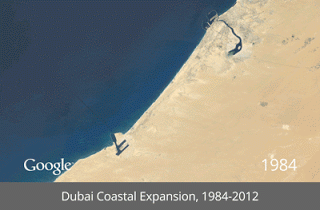
Today I am excited to share an amazing resource with you! Google maps collaborated with NASA, the US Geological Survey, and Time Magazine to present the world as you've never seen it. For students interested in geography, mapping, and ecology, these maps are a wonderful resource. Using satellite images from the past 27 years, these maps are able to show how our geography has changed. From man-made islands off the coast of Dubai, to changes in arctic ice, these maps show history unfolding before our eyes. While the project focuses mostly on the ecological and environmental effect of urban sprawl, oil harvesting, and coal mining, it is also a fascinating look at how landscapes change over time. Looking at Cape Cod, changes in the shoreline are observable if you look closely. You can zoom in on your hometown to see how it has developed over time.

The Timelapse homepage provides all sorts of information on the conception and development of the project and is sure to be fascinating to any science geeks out there! There is a fascinating video on the work that went into the project. From assembling trillions of pixels of data to using supercomputers to scrub away cloud cover, to setting up the time-lapse videos, this was a huge undertaking.

Check it out here. Enter your hometown in the "Explore the World" section and see how your town has changed. Also check out some of the videos on the impact of human action on the environment, both good and bad. Students using our Geography Through Literature may want to zoom in on the Great Lakes or the Mississippi River to see how these regions have changed in the past 27 years.
RELATED RESOURCES:

Don't forget to check out our Facebook and Pinterest pages. And if you've enjoyed this, please feel free to share using the buttons below!
No comments:
Post a Comment